The 441-acre Canaan Preserve was acquired in 2019 with a grant from the Clean Ohio Green Space Conservation Program. It connects the Baker Preserve with Strouds Run State Park.
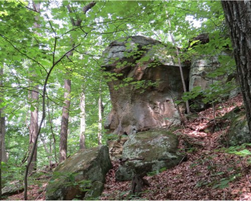
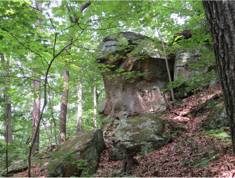
There are dramatic cliff faces, a rockhouse, and other scenic rock formations on the property. Much of the land is mature forest, but the northeastern part was clear-cut in the 1990s and is now young forest.
This land was acquired from the Couladis family, who had owned it since 1957. It became a dairy farm in the 1960s, known as the most modern one in the county at that time and the first one to have an automated milking machine.
Use iNaturalist to help document plants, mushrooms, insects, birds, mammals, and more in the Canaan Preserve.
Trails
John Knouse Trail
(1.95 miles; difficulty – moderate)
John Knouse Trail crosses Canaan Preserve, connecting with the Baker Preserve trails to the east and the Strouds Run State Park trail system to the west. Built in 2020–2022 in partnership with Buckeye Trail Association, this trail is dedicated to the memory of Athens Conservancy’s founder, John Knouse. With the construction of this trail, it is now possible to hike from Sells Park to SR-690 near Canaanville (9 miles by trail) without crossing a road.
Starting from its western trailhead, this heavily forested trail descends steadily but gradually from a ridgetop to Couladis Run. It then ascends intermittently to another ridge, which it follows to its east end on Liar’s Ridge Trail in Baker Preserve. Most grades are no more than 10%. A pair of park benches installed as an Eagle Scout project overlook a rock shelter and a seasonal waterfall at roughly the halfway point. There is also a noteworthy tree – a maple growing out of a crack in a rock face, with the base of the tree buried deep inside. See if you can find it!
Finding the John Knouse Trail
To find the western end of the trail and the parking area (“P” on map) from Athens, take Strouds Run Road into the state park and continue past the campgrounds and beach turnoffs. About a mile farther up a steep hill, there is a fork in the road. Angle to the right and follow Scatter Ridge Road 1.7 miles to the junction with Lake Hill Road, where there is a sign that says Horseman’s Area. Turn right and follow Lake Hill Road 0.5 mile to a parking area on the right. Please avoid blocking horse trailers by parking on the east (left) side of Lake Hill Road just beyond the parking lot. From there, walk south on the road another 0.2 mile and look for a trailhead sign on the left. It’s about 500 feet beyond a vehicle-exclusion gate.
The trail is also accessible at its eastern end and can be found by walking the Liar’s Ridge Trail loop through Baker Preserve. You can walk either direction from the Baker parking lot (on SR-690), but the distance to John Knouse Trail is slightly shorter if you walk the loop clockwise.
The John Knouse Trail is marked with white blazes.
Other Trails: There is a network of service roads in the preserve, which are used occasionally by the operator of several gas wells on the property. Athens Conservancy does not maintain these trails. Visitors are welcome to use them but may encounter fallen trees blocking them. There are also two short foot paths, built in partnership with Buckeye Trail Association. One of them (0.14 mile), which is unnamed, connects two service roads in the southwestern part of the preserve. The other one (0.17 mile), Canaanville Run Trail, is in the southeastern corner of the preserve. It connects a service road in Canaan Preserve with Liar’s Ridge Trail in Baker Preserve, providing a hiking loop when combined with the southeastern end of John Knouse Trail.
Volunteer Preserve Steward: Mike Rex
Maps
(click to enlarge)